Mount Sibayak
HomeToursHiking GuideAboutContactGalleryBlog
Book via WhatsApp

Trail notice: Mount Sibayak is closed to hikers 15 Oct – 15 Nov 2026 for ecosystem restoration. Treks resume once the trail reopens. Read the notice

MOUNT SIBAYAK · BERASTAGI · NORTH SUMATRA

The Mount Sibayak hiking guide — everything you need before you climb.

The routes, the costs, the weather, the gear, and the safety rules — including how to climb it on your own if you'd rather. Written by the guides who run this mountain daily since 2009.

LAST UPDATED 2026-09-21 · BY OUR GUIDES

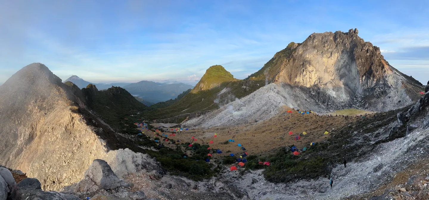
Panorama of the Mount Sibayak caldera with camps on the crater rim
THE CALDERA AT FIRST LIGHT — SHOT FROM THE RIM

The mountain in numbers.

Summit elevation
2,212 m
Berastagi elevation
1,300 m
Trail start
Pos 1 (Simpang 3), Jaranguda
Ascent time
1.5–2 hrs
Difficulty
Beginner to moderate
Summit temp before dawn
8–10°C
Daytime in Berastagi
18–24°C

At 2,212 m, Mount Sibayak is one of the most accessible volcano hikes in the region — a strong option for travelers who want a sunrise summit without a multi-day expedition.

Why hike Mount Sibayak.

Indonesia sits on the Pacific Ring of Fire and has hundreds of volcanoes, but most of them demand multi-day treks and serious conditioning. Sibayak is the exception: you get the full drama of an Indonesian volcano — roaring fumaroles, bright sulfur deposits, a crater, and a summit panorama — on a half-day walk that almost anyone in reasonable health can finish.

The other reason to come is the timing. A pre-dawn start puts you on the rim as the sun rises, lighting up the agricultural valleys of the Karo Highlands and the active cone of Mount Sinabung across the gap. It is the single best-value morning in North Sumatra.

And when you come down, the mountain hands you a recovery plan: the volcanic hot springs at its base.

How to get to Mount Sibayak.

The summit is only the last part of the journey. Most travellers start in Medan and stage through Berastagi, the gateway town about 66 km south.

Medan to Berastagi

2–3 HRS · 66 KM

The budget option is the colorful public minibus from the Simpang Pos terminal in Medan — it climbs into the Karo Highlands in roughly two to three hours depending on traffic. A private car is faster and lets you leave at whatever hour you like.

Note that catching a public bus at 02:00 for a sunrise start is genuinely difficult. Both of our tours include the transfer so you don't have to solve that.

Staying more than a night? Our guide to things to do in Berastagi covers the hot springs, market and viewpoints around the trek.
Berastagi to the trailhead

15–20 MIN BY ANGKOT

From Berastagi town it is a few kilometres to the Jaranguda trailhead. Take a local angkot (green or yellow minibus) toward Jaranguda and ask the driver to drop you at the registration post, hire a scooter, or walk it in about an hour.

Doing it yourself is easy in daylight. Doing it at 03:30 in the dark is the part most people underestimate.

The three routes up.

There are three distinct ways to the summit. Which one you take changes the difficulty, the time, and where you end up.

Jaranguda (tourist route)

Easiest · 45 min – 1.5 hrs up

The standard route and the one to use for a sunrise climb. Starts at the Jaranguda parking area as asphalt, then turns to dirt and rock. Well trodden, signposted, and registered at a checkpoint. This is where our tours climb.

Semangat Gunung (hot springs route)

Moderate · about 2 hrs up

Begins in Semangat Gunung village, home of the volcanic hot springs. Mostly concrete steps and considerably steeper than Jaranguda. Most travellers climb up via Jaranguda and descend this way so they finish at the thermal pools.

Route 54 / Pandaan

Hard · 4–6 hrs one way

A long jungle route cutting through dense rainforest for experienced trekkers only. Do not attempt it without a local guide and a proper early start.

Jaranguda is sometimes written Jarangguda — same trailhead.

Two starting points.

From Medan

A full-day Mount Sibayak hike with more scenery packed into one trip.

  • ·Full-day experience with a very early pickup from Medan.
  • ·Includes sunrise, hot springs, and Sipiso-Piso Waterfall.
  • ·Suitable for first-time visitors who want all logistics handled.
See the Medan package

From Berastagi

A shorter sunrise trek with faster access to the trailhead.

  • ·Half-day experience with a later pickup and less driving.
  • ·Sunrise summit, crater exploration, and hot springs.
  • ·Suitable for short stays or visitors already in Berastagi.
See the Berastagi package

What to expect on the trail.

On a sunrise climb you start under a canopy of stars and walk with headlamps. The first stretch is shaded forest and old asphalt; then you break the tree line and the landscape changes abruptly — lush greenery gives way to barren volcanic scree.

You will smell the sulfur before you see it. The fumaroles vent high-pressure steam with a sound like a jet engine, and the ground is stained bright yellow where the deposits collect. Follow your guide's line here: some of the crust around the vents is thin.

The crater rim is where the view opens. A short scramble up loose rock reaches the true high point, and from there you look down over Berastagi, the agricultural valleys, and the smoking cone of Mount Sinabung. If you are not sure which mountain you are looking at, our Sibayak vs Sinabung guide explains the difference.

Hikers on the rocky summit ridge of Mount Sibayak above the tree line
ABOVE THE TREE LINE — VOLCANIC SCREE TO THE RIM

Can I hike Mount Sibayak without a guide?

Yes — and we'd rather tell you how than pretend otherwise. Mount Sibayak is one of the few Indonesian volcanoes you can legally and practically climb on your own. Here is exactly what that involves.

STEP 1

Register at the checkpoint

The Jaranguda trailhead has a Karo Regency registration post. Independent hikers pay the IDR 10.000 entrance fee per person, in cash — bring small notes — plus parking if you drive or ride up yourself. If you climb with us, both the entrance fee and parking are already covered.

STEP 2

Get to the trailhead from Berastagi

An angkot (local minibus) toward Jaranguda takes 15–20 minutes — ask the driver to drop you at the registration post. Otherwise it is about an hour on foot, or a short scooter ride from your guesthouse.

STEP 3

Bring an offline map

The main route is obvious in daylight, but the trail splits in a few places. Download an offline map (Maps.me or Organic Maps) before you leave Berastagi — mobile signal is patchy on the upper slopes.

STEP 4

Start before dawn only if you know the trail

Sunrise means leaving the trailhead around 04:00 in complete darkness. The path is unlit, and near the crater the ground is loose and the fumaroles are active. That combination is where independent hikers get into trouble.

So the honest summary: if you are fit, hiking in daylight, and comfortable reading a map, you can do this mountain independently for the price of a minibus ticket, the IDR 10.000 entrance fee, and parking if you drive up. Your costs climb with every extra thing you'd otherwise hand over — the 03:30 pickup, the headlamps, the hot springs entry, and the fact that you'd be navigating the crater in the dark alone.

Where it stops being a fair trade is the sunrise version. You are navigating unlit volcanic terrain at 04:00, in the cold, with active gas vents nearby and patchy phone signal. That is the specific scenario our guides train for — and it is why most travellers who come this far choose to climb with someone who has done it a few thousand times.

There is no pressure either way. If you'd like the logistics handled, both of our treks include the guide, permits, headlamps, and the hot springs entry:

The best time to hike Mount Sibayak.

Indonesia's dry season, roughly May to September, gives you the clearest sunrises and the firmest footing. You can climb in the wet season too — the trek runs year-round — but expect slick rock and a heavier chance of cloud sitting on the summit.

Time of day matters as much as month. The pre-dawn start is what makes this mountain worth the early alarm: you want to be on the rim before the sun clears the horizon.

For a month-by-month breakdown, read our Mount Sibayak weather and best time to climb guide.

What to pack.

The summit is genuinely cold before dawn — preparation matters more than fitness on this mountain.

  • Trail shoes or light hiking boots

    Good grip matters more than ankle support on this trail.

  • A warm layer for the summit

    8–10°C with wind chill before sunrise. A windbreaker over a fleece is the right answer.

  • A waterproof shell

    Mountain weather changes quickly, in every season.

  • 1–1.5 liters of water & easy snacks

    Summit tea, coffee, and snacks are included on our tours.

  • Face mask or bandana

    Mandatory near the sulfur vents; we provide them if needed.

  • Swimwear & towel

    For the volcanic hot springs at the end of the descent.

How we keep it safe.

A pre-dawn volcano trek is only as safe as its operator. This is our standing procedure — the one behind fifteen years without an incident.

Is the mountain safe right now?

Certified guide on every departure

First-aid trained, briefed on current trail and gas conditions before each climb.

Weather-checked the night before

If conditions are wrong, we adjust timing with you rather than climb anyway.

Gas protocol at the crater

Masks required near the fumaroles, time at the vents kept short, wind direction watched.

Honest screening before booking

Asthmatic travelers and pregnant women should consult a doctor first — we'll tell you that before you pay anything.

The hot springs afterwards.

One of the best things about Sibayak is what sits at the bottom of it. The village of Semangat Gunung, right below the crater, is built around natural sulfur-rich thermal pools heated to somewhere between 40 and 45°C.

Descend via the Semangat Gunung route and you walk straight into them — the standard reward for a 04:00 start. Entry is a small local fee, and both of our treks include it.

Mount Sibayak — frequently asked questions.

How long does the Mount Sibayak hike take?
Using the easiest route (Jaranguda), expect about 1.5 to 2 hours from Pos 1 (Simpang 3) to the summit at a relaxed sunrise pace — fit hikers can do it in 1 to 1.5 hours — and about 1 hour to descend. Allow roughly 3 to 4 hours round trip including time at the crater.
Can I hike Mount Sibayak without a guide?
Yes. The Jaranguda route is well trodden and you can climb independently during daylight hours after registering at the Karo Regency checkpoint. For a pre-dawn sunrise start, most travellers prefer a guide — the trail is unlit and the terrain near the sulfur vents is loose.
Is Mount Sibayak safe to hike?
It is generally safe and monitored by Indonesian vulcanology authorities, but conditions and alert levels change. Check current updates before you climb, stay back from the fumaroles, and never enter the crater floor alone. On our treks we monitor conditions daily and adjust timing rather than climb in poor weather.
Can children hike Mount Sibayak?
Active children (usually 8 years and up) manage the Jaranguda route comfortably with proper footwear and supervision. Keep them close on the rocky crater rim.
Is Mount Sinabung safe to hike instead?
No. Mount Sinabung is highly volatile and closed to hikers. Admire it from a distance — the best view of it is actually from the Mount Sibayak summit.
Do I need to book the Mount Sibayak trek in advance?
For the sunrise trek, yes — message us on WhatsApp with your dates and hotel. We confirm availability within the hour, daily 07:00–22:00 WIB. There is no prepayment; you pay your guide at pickup.
Book